Qinghai-Gansu Silk Road Loop: Lakes, Desert & Ancient Cities
The Qinghai-Gansu Grand Loop is the most concentrated road trip in China. In seven to eight days you move from alpine lakes at 3,200 meters to sand dunes in the Gobi, passing salt flats, rainbow-colored mountains, a 1,600-year-old Buddhist cave complex, and the western end of the Great Wall. No other route in the country packs this much variety into a single week.
This is not a trip for someone who wants to sleep in and drift between cafes. The distances are real. A full loop from Xining and back covers roughly 2,800 kilometers. Some days you will spend five or six hours in a vehicle. But the payoff is waking up at Qinghai Lake one morning and watching the sun set over a 1,000-year-old Silk Road fortress four days later.
I wrote this guide for anyone considering a first trip to western China who wants practical answers: what the route actually looks like day by day, when to go, how to book the things that sell out, and what nobody tells you about the altitude, the bathrooms, and the driving.
What the Qinghai-Gansu route actually covers
The loop starts in Xining, the capital of Qinghai province, and runs clockwise through:
- Qinghai Lake — China’s largest saltwater lake, sitting at 3,200 meters, ringed by yellow rapeseed fields in July and August
- Chaka Salt Lake — a shallow salt pan that reflects the sky like a mirror on calm days
- Dachaidan Emerald Lake — smaller than Chaka but the water is a deep turquoise that photographs do not exaggerate
- Dunhuang — the Silk Road oasis where the Mogao Caves hold 45,000 square meters of Buddhist murals and over 2,000 painted sculptures, carved between the 4th and 14th centuries
- Zhangye Danxia — layered sandstone hills in red, orange, yellow, and green, formed over 24 million years
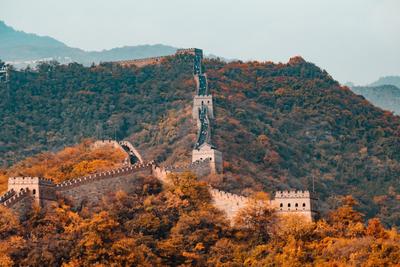
- Jiayuguan — the fortified pass that marked the western edge of the Ming Dynasty, where the Great Wall stops and the Gobi begins
Between these stops you cross the Qaidam Basin, drive the G315 highway through a landscape that looks like Mars, and climb the Dangjin Pass where Qinghai gives way to Gansu. The geography shifts every few hours: grasslands to salt crust to bare rock to sand.
Best time to go
The window for this loop is narrow. Snow closes the high passes from November through March, and some guesthouses in Dachaidan and Chaka simply shut down outside the summer season.
Late June and September are the sweet spots. July and August work and you get the rapeseed flowers at Qinghai Lake plus warm desert nights, but accommodation prices in Dachaidan and Dunhuang can double or triple and Mogao Caves A-class tickets vanish within minutes of release. September keeps the warmth but loses the summer crowds. Late June gives you the flowers without peak pricing.
May and early October are possible if you pack for cold mornings. By mid-October, overnight temperatures dip below freezing on the plateau and the Danxia colors look flat without strong sunlight. I would not start this trip after October 15 unless you know what you are signing up for.
One thing that surprises people: Dunhuang sits at only 1,100 meters. You go from 3,200 meters at Qinghai Lake down to the desert basin, so altitude symptoms usually ease after day two. The highest point on the standard route is the Dangjin Pass at about 3,800 meters, but you drive through it rather than sleeping there.
The 7-day route, day by day
This is the standard clockwise loop. You can run it in six days if you skip one stop or stretch to eight or nine for a more human pace. Seven is the floor I recommend.
Day 1: Xining to Chaka (300 km, 4-5 hours driving)
Leave Xining early. The road climbs past Riyue Mountain and then Qinghai Lake appears, a sheet of deep blue that looks like the ocean until you taste it. Stop at Erlangjian or Heimahe for a couple of hours. Lunch in the lakeside town of Heimahe, then continue to Chaka Salt Lake for late afternoon when the light is low and the crowds thin out. Sleep in Chaka town. Altitude is 3,100 meters so take it slow tonight.
Day 2: Chaka to Dachaidan (400 km, 5 hours)
Morning at Chaka if you missed sunset the day before. Then the landscape shifts: the Qaidam Basin opens up, flat and bare, ringed by distant snow peaks. Stop at Emerald Lake outside Dachaidan in the late afternoon when the turquoise water catches the slanting light. Sleep in Dachaidan town. The accommodation here is basic, book ahead.
Day 3: Dachaidan to Dunhuang (500 km, 6 hours, the longest day)
This is the big driving day. The G315 highway heads northwest past the U-shaped highway photo spot and the Water Yadan formations, strange sandstone pillars rising from a salt lake. You cross the Dangjin Pass at 3,800 meters and descend into Gansu. By late afternoon the sand dunes of the Gobi appear and you reach Dunhuang. Get to Shazhou Night Market for lamb skewers and apricot water.
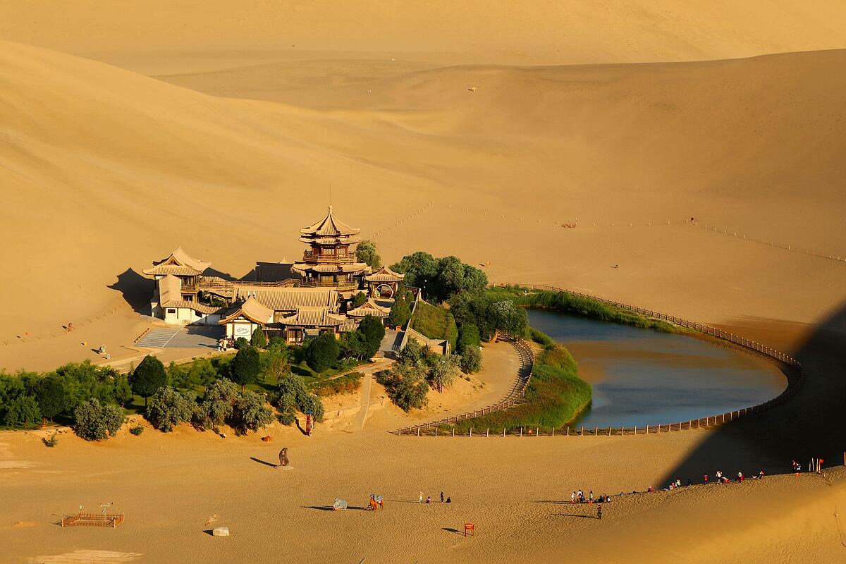
Day 4: Dunhuang, Mogao Caves and Mingsha Mountain
Mogao Caves in the morning (book A-class tickets 30 days ahead, I explain how below). You will see eight caves with an English-speaking guide if you book A-class. The murals inside Cave 45 and Cave 328 are 1,300 years old and the pigments in some panels are still bright. No photos inside. After lunch, head to Mingsha Mountain and Crescent Lake for the late afternoon. Ride a camel or just walk up the sand ridge for the sunset. The ticket is valid for three days so you can return.
Day 5: Dunhuang to Jiayuguan (370 km, 4 hours)
Drive east along the Hexi Corridor. Stop at the giant desert sculptures on the way, the Sleeping Buddha and the Son of the Earth, both modern but worth 20 minutes. Arrive at Jiayuguan Fort by mid-afternoon. Climb the tower and look north: the Gobi stretches to the horizon, and behind you the Qilian Mountains hold snow even in July. Sleep in Jiayuguan city and eat the local lamb barbecue.
Day 6: Jiayuguan to Zhangye (230 km, 2.5 hours, easiest day)
A short drive. Arrive in Zhangye by lunch. Do not go to the Danxia at midday; the colors wash out under direct sun. Enter around 3:30 or 4 PM and work your way to Viewing Platform 4 for sunset. The layered bands of red, yellow, and green are most vivid in the last hour of light. The park closes at 7 PM in summer, earlier in shoulder season. Sleep in Zhangye.
Day 7: Zhangye to Xining (350 km, 5-6 hours)
The final leg. You cross the Qilian Mountains through the Biandukou Pass. In July and August, the valley near Menyuan is covered in rapeseed flowers, an inland sea of yellow backed by snow peaks. Stop at a roadside stand for yak yogurt. Arrive in Xining by evening. If you flew into Lanzhou instead, Zhangye to Lanzhou is a three-hour high-speed train and a much easier exit.
How to get to the start point
Most people fly into Lanzhou Zhongchuan Airport and take the high-speed train to Xining. The train from Lanzhou to Xining takes about two hours and runs frequently. Flights directly into Xining Caojiabu Airport exist but are less frequent and often more expensive.
If you are already traveling in western China, you can reach Xining by high-speed rail from Xi’an, Chengdu, or Urumqi depending on your route. Xining is connected to the national high-speed network, though some connections require a transfer at Lanzhou.
Driving vs. hiring a driver
You have three options for the loop and they are not equal.
Hiring a car with a local driver is what most first-timers do. A driver who knows the route handles the six-hour days, the unmarked turnoffs to Emerald Lake, and the Dangjin Pass descent. You focus on the scenery. This costs roughly 1,200 to 1,500 yuan per person for the full loop, excluding fuel and tolls. Book through a licensed travel agency, not a random WeChat contact who offers a lower price.
Self-driving gives you freedom but comes with real friction for foreigners. You need a Chinese driver’s license, which requires a separate test beyond the provisional license. Some sections of the G315 have no mobile signal for 30 to 40 minutes at a stretch. Fuel stations are spaced far apart in the Qaidam Basin. If you self-drive, download offline maps in Gaode or Baidu before you leave Xining and never let the tank drop below a quarter. For more on the license and rental process, see the China road trip guide.
Joining a group tour is the cheapest option. You will be on a bus with 20 to 30 people on a fixed schedule. You will not choose your photo stops. This works fine for some travelers but on a route where the scenery changes every hour, the lack of flexibility is frustrating.
I recommend option one for a first trip. The cost difference between a private car and a group tour on this route is about 500 yuan per person and it buys you control over when you stop, where you eat, and how long you spend at each place.
Booking Mogao Caves tickets
This is the single point of failure on the entire loop. Mogao Caves A-class tickets (which get you into eight caves with a guide) sell out. You cannot buy them at the gate during peak season.
Book through the official WeChat mini-program “莫高窟参观预约” (Mogao Caves Visit Reservation) or the website at www.mgk.org.cn. Tickets for peak season dates in July and August are released 30 days in advance and disappear within minutes for popular dates. Set a calendar reminder for 30 days before your planned Dunhuang day and book at 8 AM Beijing time.
A-class tickets cost 238 yuan. B-class tickets (four caves, no guide, shorter visit) cost 100 yuan and are the fallback if you miss the A-class window. They are sold on a different schedule so check the official site for current release dates.
If you travel in winter (December through March), the situation reverses. You can visit up to 10 caves on a discounted ticket and the crowds disappear. The tradeoff is cold: Dunhuang in January averages minus 8 degrees Celsius.
The Mogao Caves were inscribed as a UNESCO World Heritage Site in 1987 and the designation covers 492 preserved cells and sanctuaries carved into a cliff face running 1,600 meters. The Library Cave, sealed around 1036 AD and discovered in 1900, held nearly 45,000 manuscripts in multiple languages including Chinese, Tibetan, Sanskrit, and Sogdian. That one cave rewrote what historians know about Silk Road trade.
Altitude: what to expect
Qinghai Lake sits at 3,200 meters. The Dangjin Pass reaches 3,800 meters. Most people on this route get a mild headache on day one and feel normal by day three. A few things help:
- Spend your first night in Xining (2,200 meters) before starting the loop. One night of partial acclimatization makes a difference.
- Do not drink alcohol on the first two days. It hits harder at altitude and makes sleep worse.
- Drink more water than you think you need. The plateau air is dry and dehydration worsens every altitude symptom.
- Pack ibuprofen for headaches and a few packets of electrolyte powder.
If you have been to Tibet and handled Lhasa at 3,650 meters, this route will feel easy. If you have never been above 2,000 meters, the first 24 hours might be uncomfortable but rarely dangerous at these elevations.
Real talk: the altitude is manageable for most people but the bathroom situation on the road is not. Between Chaka and Dachaidan, facilities are squat toilets at best and open ground at worst. Carry toilet paper, hand sanitizer, and spare tissues. If this is a dealbreaker for you, this route is not a good fit.
What to pack
The temperature swing is the main packing challenge. A July day might hit 28 degrees in Dunhuang and drop to 8 degrees at night in Dachaidan. You need layers, not heavy clothing.
- A windproof outer layer. A lightweight shell jacket works.
- A fleece or thin down jacket for evenings on the plateau.
- SPF 50 sunscreen, a wide-brimmed hat, and sunglasses. The UV at 3,000 meters burns in 15 minutes even on overcast days.
- Lip balm and moisturizer. The air in the Qaidam Basin is dry enough to crack skin.
- Comfortable shoes you can walk three to four hours in. You will climb sand dunes, walk salt flats, and stand on viewing platforms.
- A power bank. Some stretches have no charging ports and your phone running GPS will drain faster than you expect.
- Cash. Most places accept WeChat and Alipay but small roadside stalls in Qinghai sometimes do not.
One item that gets overlooked: a buff or light scarf. Useful as sun protection on your neck, a dust mask on windy days at the Danxia, and a face cover if the sand picks up at Mingsha Mountain.
What this route is not
The Qinghai-Gansu loop is not a relaxing vacation. The days are long, the altitude is uncomfortable for the first 24 hours, the bathrooms between Chaka and Dachaidan are memorably bad, and you will eat mediocre food at highway rest stops more than once.
It is also not a budget backpacker route in the way Yunnan or Guangxi can be. The fixed costs, private car or driver, accommodation in small towns with limited supply, and attraction tickets add up. Budget roughly 5,000 to 7,000 yuan per person for a seven-day loop with a private driver, excluding flights to Xining.
Worth it?
I would say yes, with one condition: you need to accept that the driving is part of the experience, not an obstacle to it. The stretch from Dachaidan to Dunhuang, where the Qaidam Basin gives way to sand dunes across 500 kilometers, is as memorable as any single attraction on the route. If you treat that as dead time between photo spots, you will hate this trip. If you let the landscape do its work, it delivers.
The Qinghai-Gansu travel route is the kind of trip where you check your phone at the end of the week and realize you took 400 photos and none of them capture what the salt lake looked like at 7 PM or how cold the wind was on the Jiayuguan tower or what the Mogao Cave murals smelled like, old clay and dust and centuries.
For a deeper dive into the broader region, the Xinjiang first-timer guide covers what happens if you keep going west past Dunhuang into China’s far northwest. The Silk Road does not stop at Jiayuguan.